The bridge on the Swing Bridge's line
Before 1771 this was the only bridge over the Tyne at Newcastle. It stood where the Swing Bridge stands now; one of its land arches is still under the Swing Bridge's Newcastle end.
 Cairn
British History Quest

Every November Britain remembers those who died in war. Poppies grew on the churned-up battlefields of Flanders, and at eleven o'clock on 11 November 1918 the guns of the First World War fell silent.
The day the guns fell silent →Around 1740 · thirty years before the Great Flood
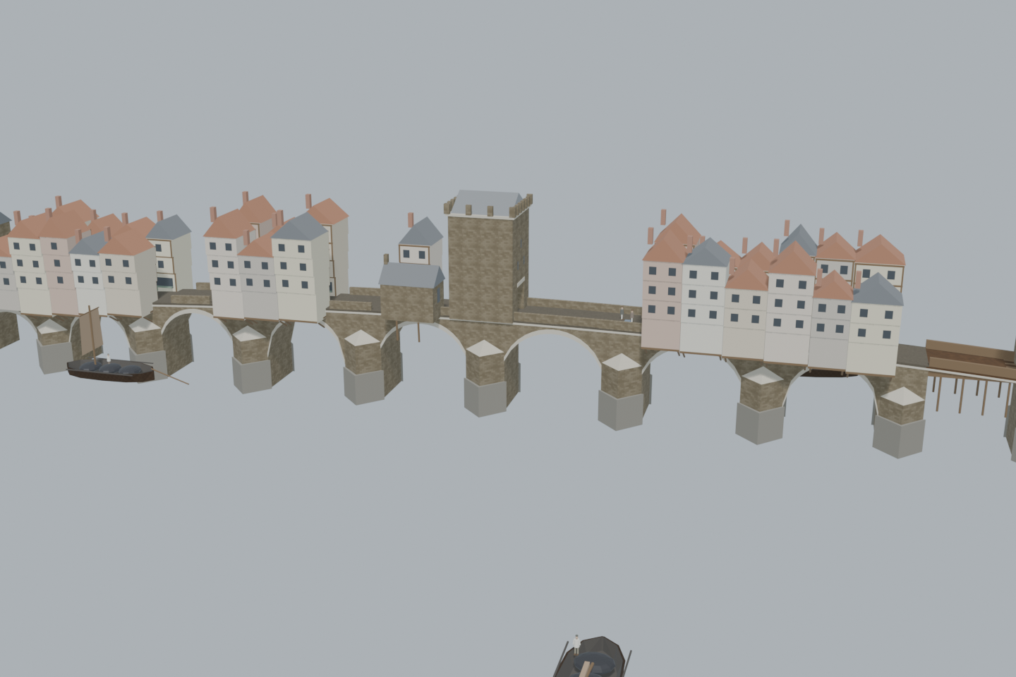
The medieval stone bridge between Newcastle and Gateshead as it stood in the generation before the flood of November 1771 swept it away: ten arches of different sizes, a street of timber houses and shops along it, the Great Tower in the middle, the Blue Stone where Newcastle's part ended and the Bishop of Durham's began, and the Magazine Gate at the Newcastle end with King Charles II in Roman dress. Keels pass under the Keelmen's Arch with their masts lowered. It stood where the Swing Bridge stands today.
View from anywhere. No camera or location permission needed.
4.2 MB · downloaded on demandDrag to orbit; scroll or pinch to zoom; right-drag or two-finger drag to pan. With the viewer focused: arrow keys rotate, +/− zoom, 0 resets.
Inside the green area the camera view shows the scene from where you really stand, at your real height — on a bridge you look down on it. Outside the area the app shows it from the marked demo point instead. Select a point on the map to check it, then load the 3D scene to preview the view from there.
The placement is a desktop reconstruction lined up with today’s map; it is not a surveyed position. Access, closures and sightlines on the ground are not checked.
Select a point on the map. Your location is requested only when you press “Check my location”.
Walk the old bridge in the 1740s: a crowded street of shops and houses over the river, half Newcastle's and half the Bishop of Durham's.
The people, keels and carts are fictional illustrations, not records of particular people.
Load the 3D scene to visit these viewpoints.Before 1771 this was the only bridge over the Tyne at Newcastle. It stood where the Swing Bridge stands now; one of its land arches is still under the Swing Bridge's Newcastle end.
At the Newcastle end the gate tower held the town's powder. In front of it stood Charles II, carved in Roman dress. A bookseller kept a shop under the gate.
Timber houses and shops lined both sides, their backs hanging out over the water on struts from pier to pier. The street between them was narrow, and carts creaked along it.
South of the Great Tower a blue stone in the roadway marked the border: north of it was Newcastle, south of it the Bishop of Durham's. The stone survives in the Castle Keep.
The keels that carried coal down to the colliers lowered their masts to shoot the arches. The seventh from Newcastle, in mid-stream, was the Keelmen's.
After days of rain the Tyne rose twelve feet above high water. At about three in the morning the middle arch and two near Gateshead fell, with the houses on them. The bridge was never repaired.
An evidence-informed study. The line (the Swing Bridge's), the length (560 ft, twelve arches of which the landward ones were built over), the order of the named arches and piers, the three towers, the Blue Stone and the houses on both sides follow the Tyne and Wear HER, Hutchinson (1785) and Clephan (1886). Individual spans, the height of the roadway, the width of the street, the houses' forms, the chapel's place and all daily activity are interpretive; the view of the river is today's banks, not the wider 1740 river. Not a surveyed reconstruction or an approved on-site AR installation. Horizontal placement uses a user-selected demonstration anchor.
On the line of the Swing Bridge; 560 ft long. The exact ends are placed, not surveyed.
Ten arches of differing span, the largest in mid-stream, massive piers with cutwaters, some arches pointed and some segmental ('some of them Gothic, and others scheme arches'). Spans and heights are interpretive.
The Great Tower on the fifth pier, the Blue Stone on the boundary pier south of it, the south tower by the Drawbridge Arch, whose drawbridge had long been a fixed timber floor.
The 17th-century gate tower at the Newcastle end, with the statue of Charles II in Roman dress in front of it.
Timber houses three and four storeys high on both sides, overhanging the river on timber struts; the densest stretch south of the Blue Stone. Number, frontage and form of each house are interpretive.
The bridge chapel with its priest near the central tower, shown as a small stone building on the west side.
Keels with their masts lowered under the Keelmen's Arch, a carter, shopkeepers and passers-by; individuals and actions are invented.